You’ve heard there is a brand new BC Marine Trails member map — so what’s all the fuss about? From a brand new user interface, to a functional mobile version, improved trip planning capabilities, public site condition reports, and more, there is a lot to get excited about. So what are you waiting for? Whether you’re simply exploring what’s on offer, or planning your next adventure, you’ll want to see what’s new.
Find how-to videos on all map features to help you get started.
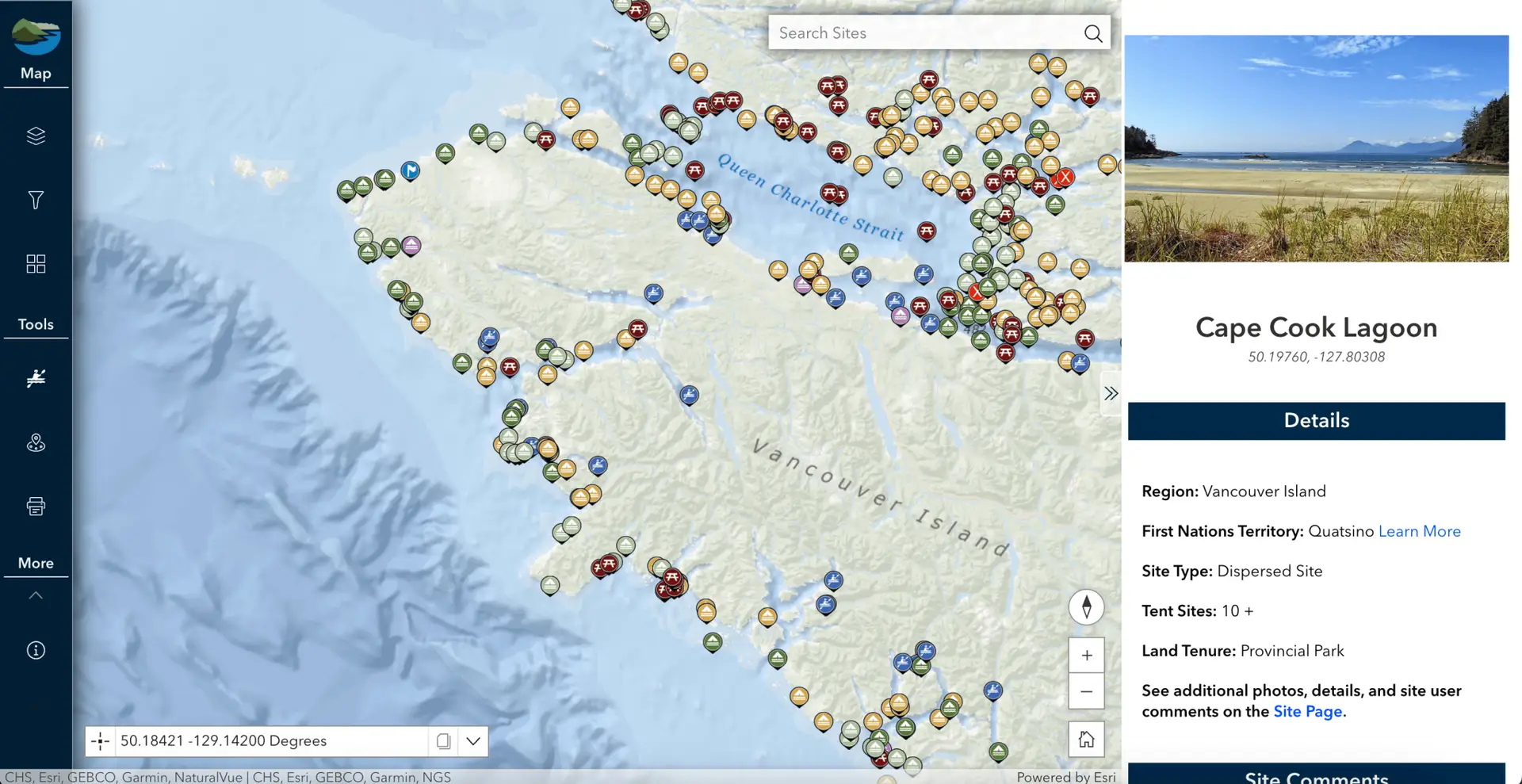
Less clutter and more information — exactly what you need to plan your next expedition. A new scrolling side bar replaces the old site pop-up — here, find site details, First Nations information, and multiple photos (finally!).
On the left, easily toggle on and off trip planning tools, choose layers, base maps, and more!
Base map 'Oceans' in use above
Public Site Condition Reports
Site Condition Reports are now visible on the member map — that’s right, you will now be able to see the most up-to-date information possible for your trip planning. Displayed reports (shown by orange pins) will include important information on conditions, photos, and more.
Head to the layers section of the map and toggle on ‘Site Condition Reports’.
Please note that we have overhauled our reporting system, resulting in only NEW reports appearing on the map.
Click on a pin to see a report — scroll down for photos
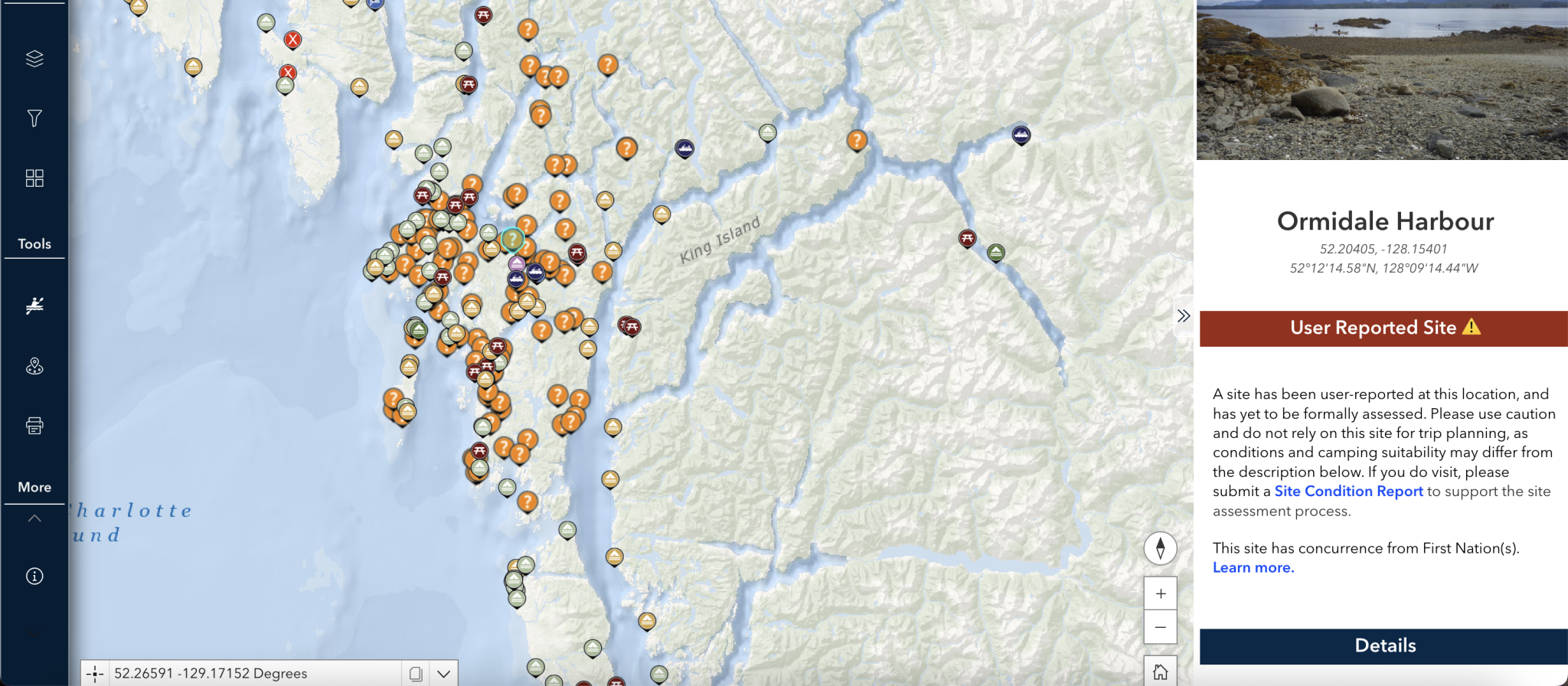
View User Reported Sites
A new layer of user-reported sites is now visible on the BC Marine Trails map in Heiltsuk Territory (much of the Central Coast)! These locations were submitted through Site Condition Reports, then reviewed by our partners at the Heiltsuk Nation for concurrence, but haven’t yet been verified for safety or camping suitability.
If you visit a reported site, please submit a Site Condition Report. Your observations help BCMT and the Heiltsuk Nation evaluate these sites and provide better info to others.
Head to the layers section of the map and toggle on ‘User Reported Sites’.
User reported sites indicated by an orange ( ? ) icon
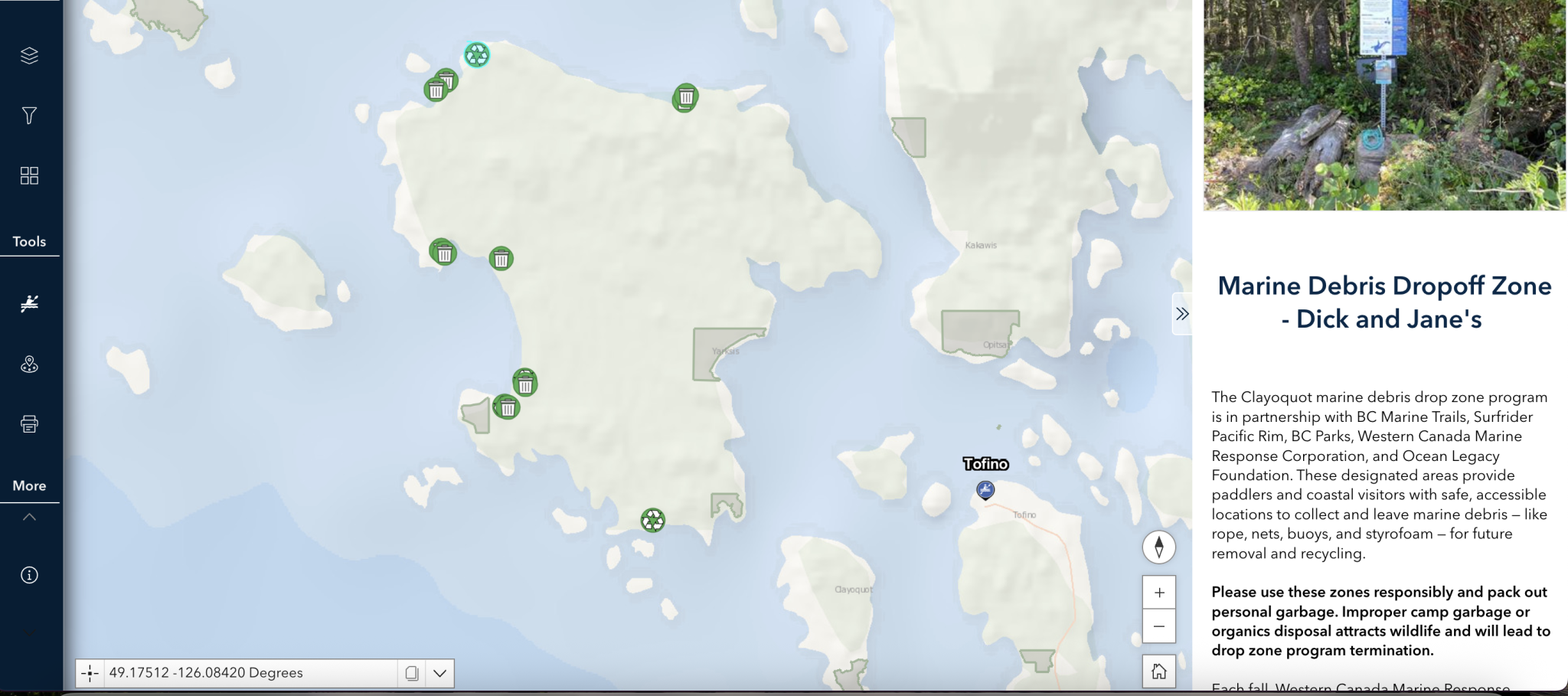
Marine Debris Layer
Our new marine debris layer is a major milestone in recreation-led stewardship! We believe every coastal visitor can make a difference, and we’ve been working hard to build tools that make it easy.
This new layer displays designated debris drop zones, along with areas where debris has been reported through Site Condition Reports (SCRs). By making debris hotspots visible and actionable, it helps us better coordinate with cleanup partners.
If you see debris, pile it above the high tide line (or add to an existing pile), snap a photo, and submit a report. Every report empowers YOU to make a real impact.
Toggle on and off in the layers tab
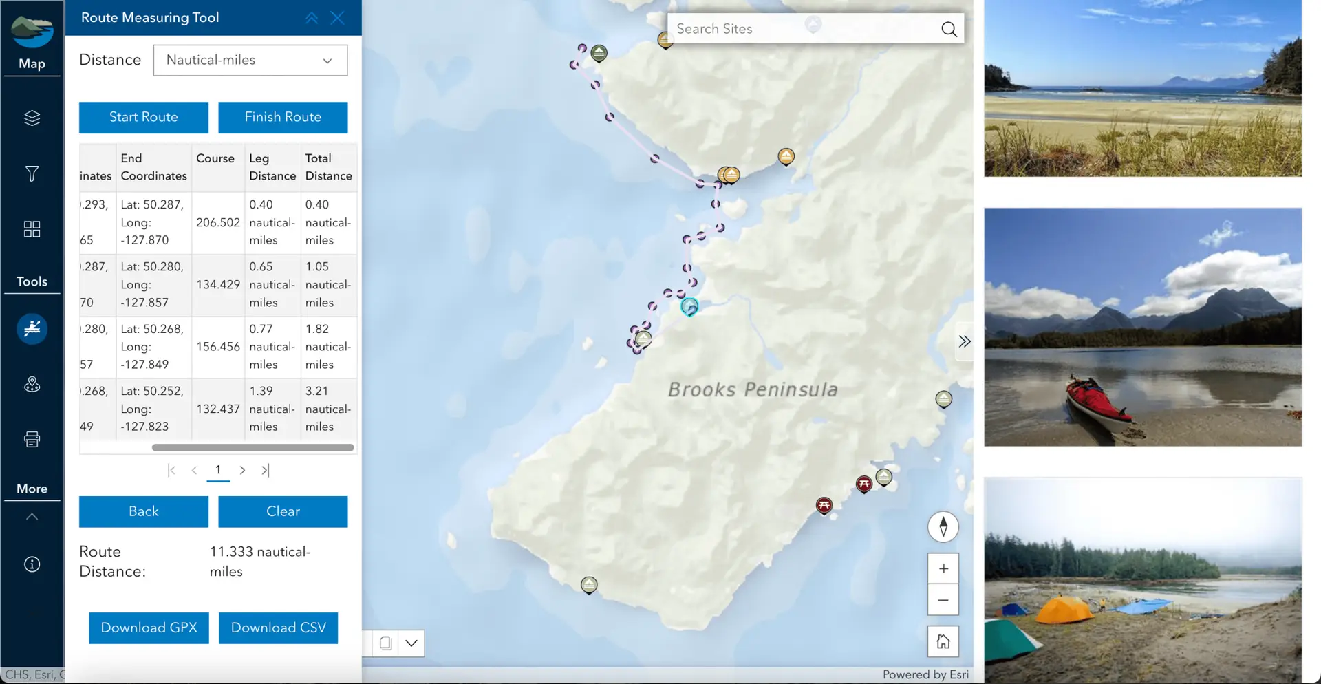
Route measuring tool
The new route measuring tool could not be any easier to use. Visualize your route, record headings, leg distances, and easily export to to your GPS device.
Site selection tool
Define a radius, draw a line, or draw a polygon and find sites within the defined proximity distance. After finding the sites and exporting them to CSV you can import the CSV file into Google Earth Pro or go to the BCMT Data Conversion Tool to convert from CSV to KML or GPX.
Then, site data can be uploaded directly to your GPS device.
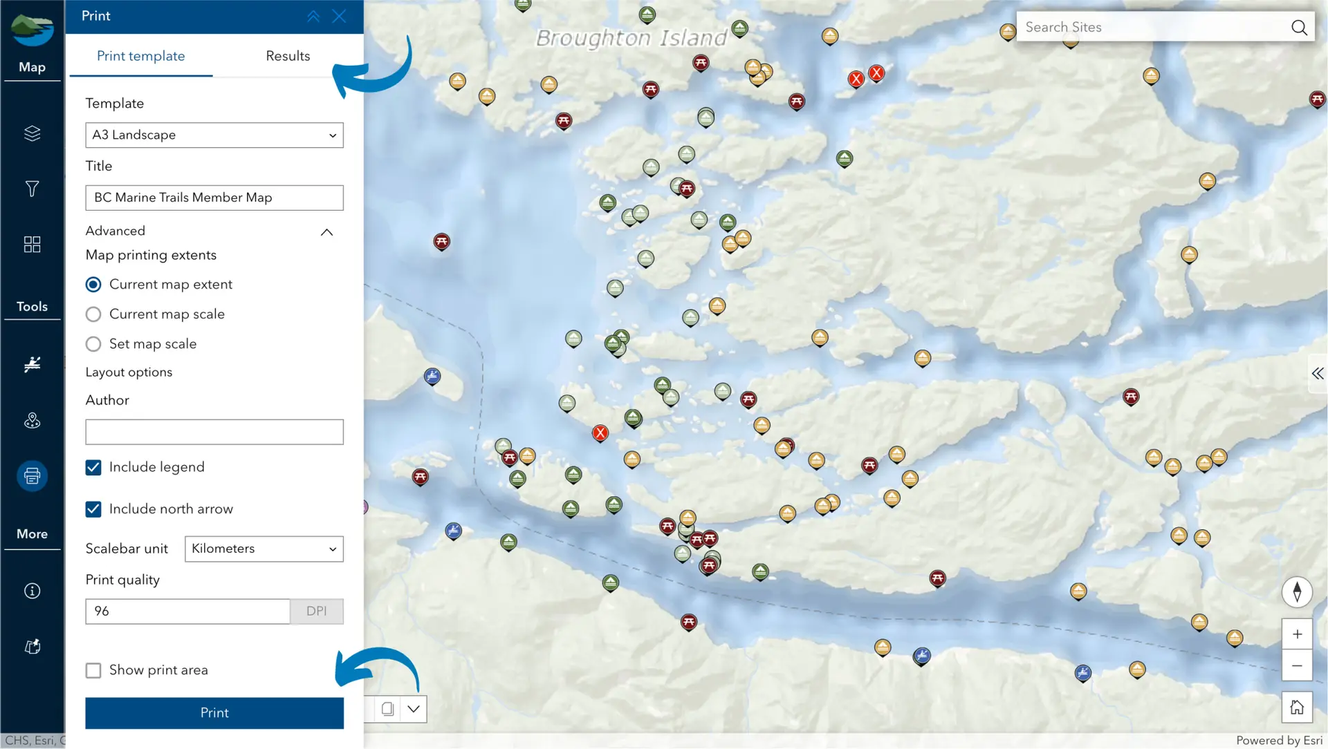
Print tool
Easily print discrete sections of the map to bring with you in the field! Choose from a variety of features to be shown on your PDF, then click ‘Print’. Your download will then be ready under the ‘Results’ tab on the top bar. Due to system limitations, scale bar units cannot show Nm.
We use basic cookie information to track things like which pages are viewed by visitors, in order to help improve our content. This information is used within Google Analytics, but is not provided to third parties.
By continuing to use this website, you consent to the use of cookies in accordance with our Privacy Policy, which can be found at the bottom of this page.