Find a video walkthrough of loading the SCR form on the app here.
To download the Survey123 app, search ‘Survey123’ in the App Store, or Google Play Store. You should see the following icon:

Once downloaded, you will need to download the SCR form to the app. To do so, return to this page, and click ‘Go to form’ above. At this point, the SCR form should be available through the app.
If preferred, you do not need to use the app — it is always an option to record information in your notes app, notebook, etc. and then fill in the form in your browser from your laptop / desktop computer. To do so, click ‘Go to form’ above, and select ‘Open in browser’.
When using the Survey123 app, report forms can be filled out in the field, and they will automatically upload when you are back in service / wifi!
Alternatively, you can record relevant information in a waterproof notebook, and upload your findings when you are back home!
The printable PDF version of the SCR can be helpful — print off one for each site, or use only one as reference for your notebook.
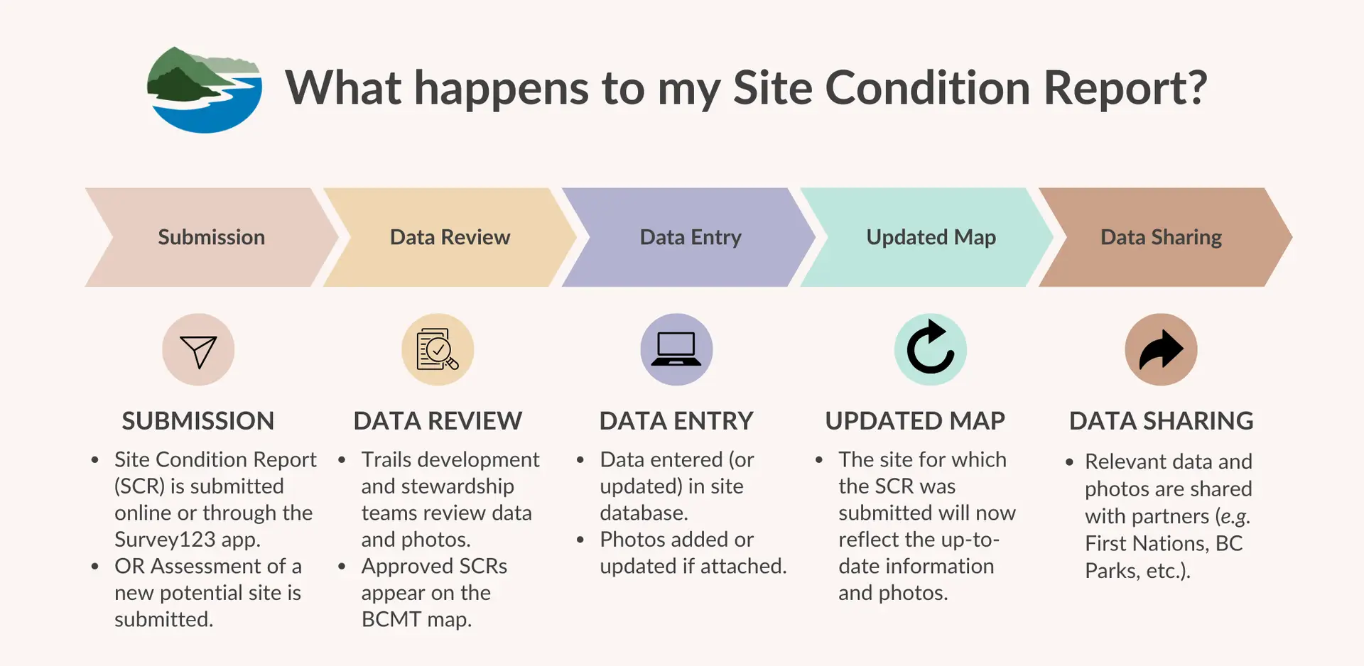
For more help, and inspiration, check out our “Site Condition Reporting While Off-Grid: A Guide for Paddlers” blog post.
- Begin by thinking about what you read from the BC Marine Trails map before coming to this site. Was there something more you would have liked to know about the landing, the camping possibilities, any evidence of trampling? Did you find examples of rare flora and fauna other visitors might like to know about?
- While you are at a site, what suggestions can you make in your Site Condition Report (SCR) to keep the site pristine for others to appreciate? (e.g. recommending a composting outhouse or green throne may not result in a new outhouse for your next visit, but in heavily used sites, these recorded observations help build a case for preserving the natural site). The same is true for a clearly marked trail in heavily used sites instead of having everyone trample the flowers.
- Some sites have Visitor Logs and while visitors may have written in the logs, that data may not have been shared. Taking a photo of the contents of the log and sharing it with your Site Condition Report (SCR) is another way to give voice to the site, not just your voice but other visitors’ voices too.
- BC Marine Trails is able to post relevant information on the map for a specific site so users are aware of potential hazards or issues identified.
- Depending on who manages the land, action may or may not be taken to address the maintenance concern raised. For example, if the land is managed by BC Parks, Recreational Sites and Trails BC, or First Nations communities, the information is passed along for the land managers to decide what to do with the resources and time they have.
- If it is a small, manageable amount that can be removed and you have space, remove the debris and put it in with your household garbage or recycling after your trip is complete.
- If you are leaving the debris at the site, collect and sort the debris, then store it far above the high tide line, in a place well above any logs. You want to avoid the debris being redistributed into the ocean once storm surge and king tides arrive in the winter months. Take photos to submit with your SCR to show the location, quantity and type of debris. We will pass off your report to organizations that may be performing large scale cleanups in the region.
- A few sites may have a collection sign indicating that debris materials can be stored by the sign for future clean up activities. This is rare at the moment, but kudos to those who are setting up debris collection sites for easy removal at a later date!
- Please note in your Site Condition Report if you completed any clean up actions and include photos of the debris too!
Not yet! If you take a short video of your site, send it to our new communications outreach coordinator, Sam (scutcliffe@bcmarinetrails.org), and he may ask your permission to use it in our social media communications.
- Minimum size is 1280 x 720 px and under 12 MB.
- Take photos that provide users with better visuals about what to expect or watch for at a site: views of the approach, the landing, the tent site, geo location of debris and quantity/type, as well as location of any hazards (dangerous trees, buried metal).
At this time, land managers (BC Parks, Recreational Sites and Trails BC, Parks Canada, and some First Nations communities working with us) receive SCR data that is pertinent to their area, including which sites were cleaned and which sites need repairs.