Renew your Membership
Thank you for continuing to be a BC Marine Trails, you are helping us build a world-class network of campsites and access points along the BC coastline. Your support goes directly towards our Trails Development, First Nations Engagement and Stewardship efforts, which enable conversation and action towards long-term coastal access with minimal impact on the environment. It’s a big goal, but with your help we’re one step closer to it!

Individual
Standard membership option- Access the member map with advanced trip planning tools & Site Condition Reports
- View multiple photos per site
- Extensive discounts on gear and services
- Exclusive member-only Facebook group
- Access exclusive content from experienced paddlers

Family
Bundle within a household and save- All of our individual member benefits
- Membership cards for your household

Business
Ideal for outfitters and guides- All of our individual member benefits
- Opportunity to provide member discounts
- Collaborate with us on social media
Membership Benefits
Our public map has several basic features, but we’ve saved the best for our members. Route measurement and planning tools, additional layers to see the latest Site Condition Reports from other members, site selection tool and multiple photos of each site.
There is an incredible amount of experience within our community. We want to share this knowledge with our members, from tips and tricks for new paddlers, to talks offered by experts as part of our Speaker Series, exclusive articles in our Coastal Cafe and a members only Facebook Group.
Our member only Facebook Community Group allows you to post comments and seek advice from hundreds of members already signed up.
Note: The list below is updated twice a year. Please check with company to confirm benefit.
Member Discounts
Telegraph Cove: 20% off 1/2 day whale watching and zodiac tours. Victoria: 20% off sunset whale watching.
10% off all kayaking and canoeing. Includes Cowichan Bay Kayaking.
Member Map Benefits
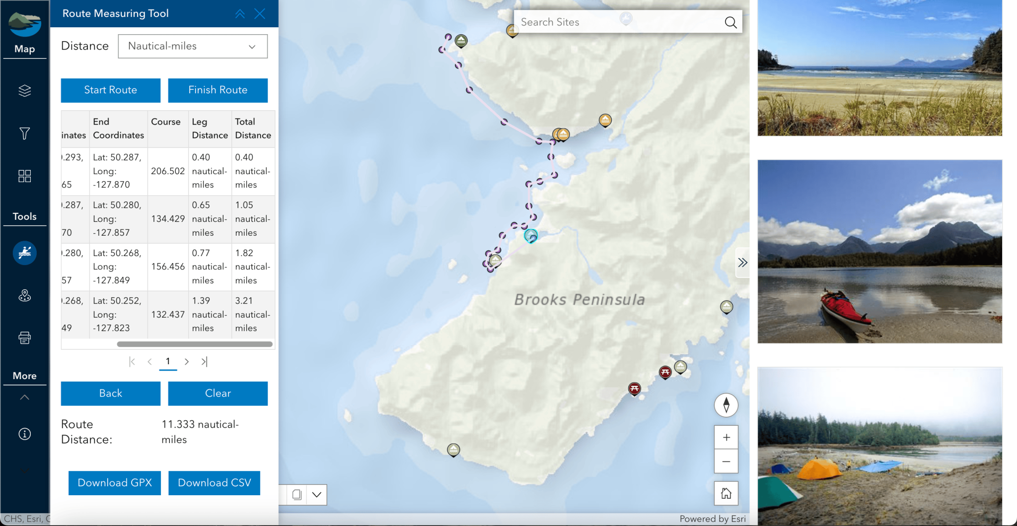
Our public map has several basic features, but we’ve saved the best for our members. Plot your route with bearing, distance, and coordinates for each leg of your trip, then export to your handheld GPS device, print it or save as a PDF to share with your friends.
Site Condition Reports are now visible on the member map — that’s right, you will now be able to see the most up-to-date information possible for your trip planning. Displayed reports (shown by orange pins) will include important information on conditions, photos, and more.
Define a radius, draw a line, or draw a polygon and lasso sites within the defined proximity distance. After finding the sites, and exporting their data to CSV, you can import the CSV file into Google Earth Pro or go to the BCMT Data Conversion Tool to convert from CSV to KML or GPX.
Then, site data can be uploaded directly to your GPS device.
Information about individual day-use and campsites is available on our map. Through your membership login, you’ll be able to see all available photos of the site. The public map has only 1 photo